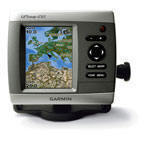
PRICE £450.00
The sleek GPSMAP 450s features preloaded detailed maps for the U.K. as well as an ultra-bright 10 cm QVGA display; built-in, satellite-enhanced worldwide basemap and simplified user operation.
The 450s includes detailed coastal maps for the U.K. as well as a worldwide basemap of satellite images for other areas. The 450s also has an SD™ card slot that makes it easy to add additional maps without connecting to a computer. With just a few buttons and a simple, intuitive interface, the 450s makes navigating your way through the water easy.
The sounder version, GPSMAP 450s, has the option of connecting a powerful dual frequency transducer that clearly paints depth contours, fish targets and structure when you’re fishing. The 450 and 450s are also CANet® compatible, so you can share sounder data with another chartplotter on your boat.
With the optional BlueChart g2 Vision SD card, you can add a whole new dimension of exceptional features to your chartplotter.
3D mariner’s eye view or fish eye view provides you with a 3-dimensional perspective of chart information, both above the waterline and below it.
High-resolution satellite images and aerial photographs help you orient yourself in unfamiliar areas.
Auto Guidance technology searches through all relevant charts to create a route you can actually follow — one that avoids obstacles, shallow water, buoys and other obstructions.
Comes complete with dual frequency transducer.